The El Niño now building in the Pacific Ocean is on track to be one of the strongest on record, and there is a better-than-even chance it will beat every event since 1950. That was the message of the monthly update from the US National Oceanic and Atmospheric Administration (NOAA), released on 12 November. In India it lands at an awkward moment: the monsoon has already ended well short of normal, reservoirs are emptying, and winter crops are being sown late.
This explainer sets out what NOAA said, what it means for India, and which parts are still forecasts rather than facts.
What NOAA said
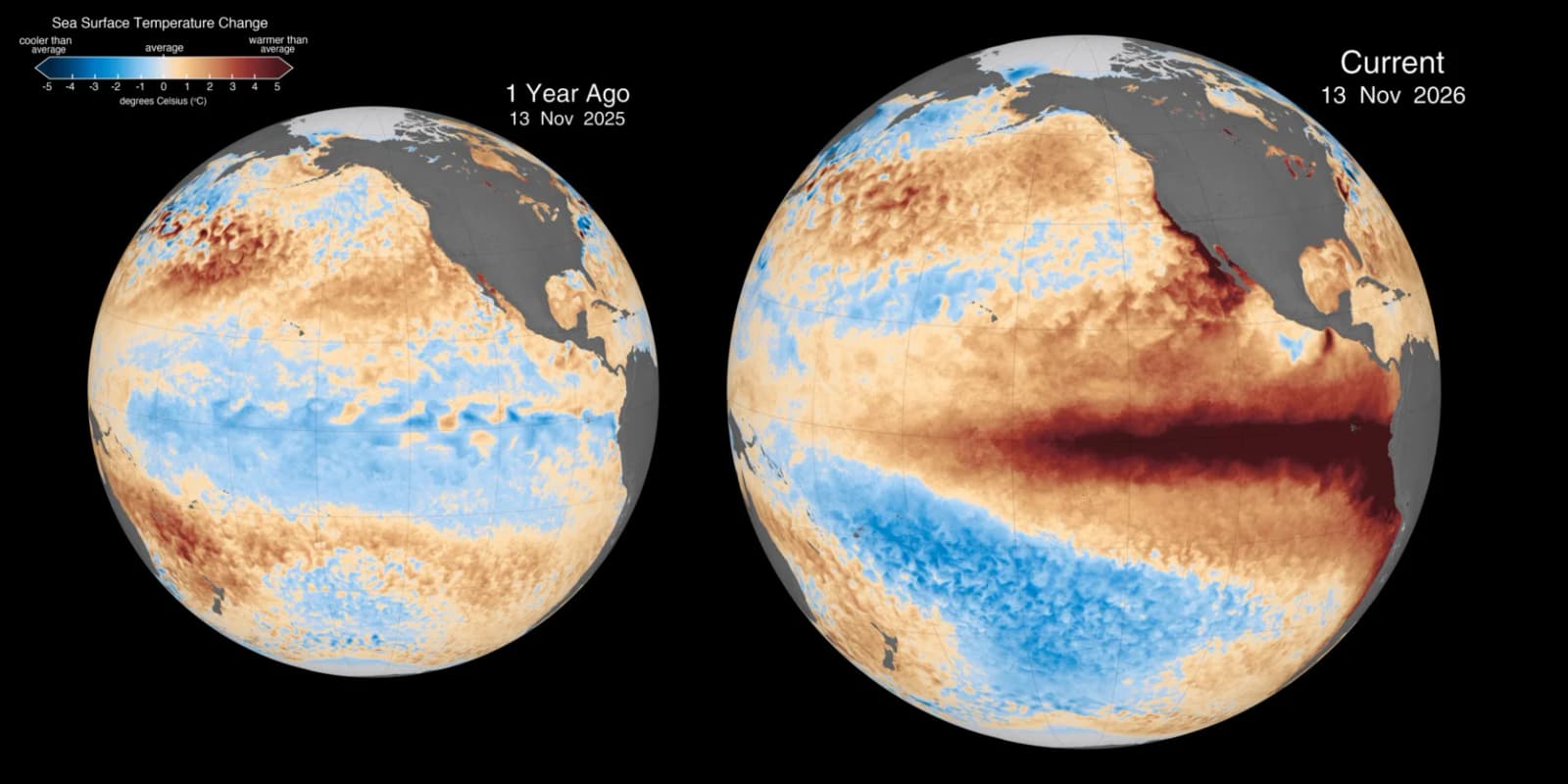
NOAA's Climate Prediction Center kept its "El Niño Advisory" in place and said the event "continues to strengthen". It put the chance of a strong-to-very strong El Niño lasting through January–March 2027 at more than 79%.
The ocean readings are extreme. In parts of the eastern equatorial Pacific, sea surface temperatures were more than 4°C above normal, the centre said, and the warmth had spread further west. The Niño-3.4 index, the main yardstick, stood at +2.5°C. The Niño-3 region was at +3.6°C and the area off South America (Niño-1+2) at +4.4°C. Below the surface, some waters in the eastern Pacific were more than 10°C warmer than average. Rainfall was enhanced over the central and eastern Pacific but suppressed over Indonesia, which is the pattern typical of El Niño.
For the "strongest since 1950" label, NOAA uses a three-month average called the Relative Oceanic Niño Index (RONI). An event would count as historic if that average reached +2.5°C or more. NOAA puts the chance of this at about 60% for both October–December and November–January. It expects El Niño to keep strengthening and then start weakening in early 2027.
Why "record" depends on the yardstick
The odds have fallen. According to the World Health Organization's El Niño response plan, NOAA's 8 October update gave an 83% chance that October–December would exceed any event since 1950. It is now about 60%.
The answer also depends on which index is used. As reported by The Weather Channel, the August–October RONI was 1.97°C, just below the 2.07°C recorded in 1997. The highest three-month RONI on NOAA's books is 2.4°C, from December 1982 to February 1983. The World Meteorological Organization's October seasonal update, as quoted in the WHO plan, used a different measure. It forecast a Niño-3.4 anomaly of about +3.7°C for October–December, against the previous record of +2.6°C set in 2015–16.
Either way, the gap between this event and the record-holders is now small. NOAA also cautions that a very strong El Niño makes the usual effects "higher, though not guaranteed".
India has already felt it
The India Meteorological Department (IMD) linked this year's weak monsoon to El Niño. India received 759.4 mm of rain between June and September, against a long-period average of 868.6 mm. That is 12.6% below normal and the weakest season since 2015. East and northeast India were the driest, about 26% short.
At the end of the season, IMD Director General Mrutyunjay Mohapatra said strong El Niño conditions prevailed over the equatorial Pacific and were expected to peak in November. He said rainfall was likely to stay below normal across most of the country through December, except for parts of the south and northwest. He also said about 38% of districts had received deficient rain.
Reservoirs and rabi sowing are the pressure points
The latest Central Water Commission bulletin, dated 12 November, shows the strain. India's 178 major reservoirs held 116.854 billion cubic metres (BCM), or 63.25% of usable capacity. That was 5.07 BCM less than a week earlier, about 30% below the same time last year and nearly 20% below normal, according to an analysis of the bulletin by Down To Earth.
The south is worst off. Its 50 reservoirs were under 40% full, almost 47% below normal. Reservoirs in Andhra Pradesh were at 27.54% of capacity, Telangana 33.49% and Tamil Nadu 36.28%. In the west, Maharashtra declared 305 talukas in 33 districts drought-hit on 14 October. Gujarat has declared 80 tehsils in 14 districts drought-affected, the report said.
Sowing of winter crops is lagging too. As of 6 November, rabi crops covered 108.66 lakh hectares, 17.21% less than the 131.26 lakh hectares a year earlier, according to Agriculture Ministry figures cited in market reports. Rapeseed and mustard were down 25.39% and gram 21.61%. Wheat was 12.02% lower, though wheat is mostly sown later.
Some farmers are already changing crops. In the Yellareddypet cluster of Telangana's Siddipet district, at least 25 farmers plan to grow horse gram, which needs little water, on about 80 acres instead of paddy or maize, Telangana Today reported on 14 November. Agriculture extension officer T Nagarjun is promoting the crop.
The health angle
On 2 November the WHO published a global preparedness and response plan for El Niño. It covers October 2026 to September 2027, runs as a "Grade 3" response, and seeks about US$35 million for the first six months. Grade 3 is the WHO's internal label for a major emergency operation. The plan says it is separate from any declaration under the International Health Regulations, so it is not a global public health emergency in the legal sense.
For the South-East Asia region, which includes India, the plan expects drier and hotter conditions in many areas. The health risks it lists include heat illness, food insecurity and malnutrition, cholera and diarrhoeal disease, leptospirosis, and dengue and malaria. For South Asia it says rabi decisions, drought and heat matter now, winter rainfall becomes important next, and snowmelt and flood risks may come later.
Several Indian outlets reported on 13 November that a WHO situation analysis lists India among the countries at high risk. We have not been able to see that document ourselves.
What it means for readers
- Prices: food inflation had already risen for seven straight months to 5.95% in August, before the monsoon ended. Smaller rabi plantings of mustard and gram could keep pressure on edible oil and pulse prices if the shortfall persists. Final output is not yet known.
- Water: people in southern states, where reservoirs are lowest, could face supply curbs before next year's monsoon.
- Health: the WHO plan names heat and mosquito-borne diseases among the main risks, so local health advisories are worth following.
- Weather: the IMD has signalled a drier-than-normal end to the year for most of the country.
What is established and what is not
Established: El Niño is strong and still strengthening. The 2026 monsoon fell 12.6% short. Reservoir storage and rabi sowing are well behind last year, according to official data.
Not settled: whether this event will officially become the strongest since 1950 (about 60% likely, by NOAA's measure); how much of the winter crop will be lost; and how El Niño will behave as it weakens in 2027, including any effect on next year's monsoon. No agency cited here has issued a forecast for the 2027 monsoon.
What happens next
NOAA's next El Niño update is due on 10 December. Watch for the IMD's monthly outlooks, the weekly reservoir bulletins from the Central Water Commission and the Agriculture Ministry's rabi sowing figures. Together they will show whether the late sowing catches up or the shortfall becomes a lost harvest.