
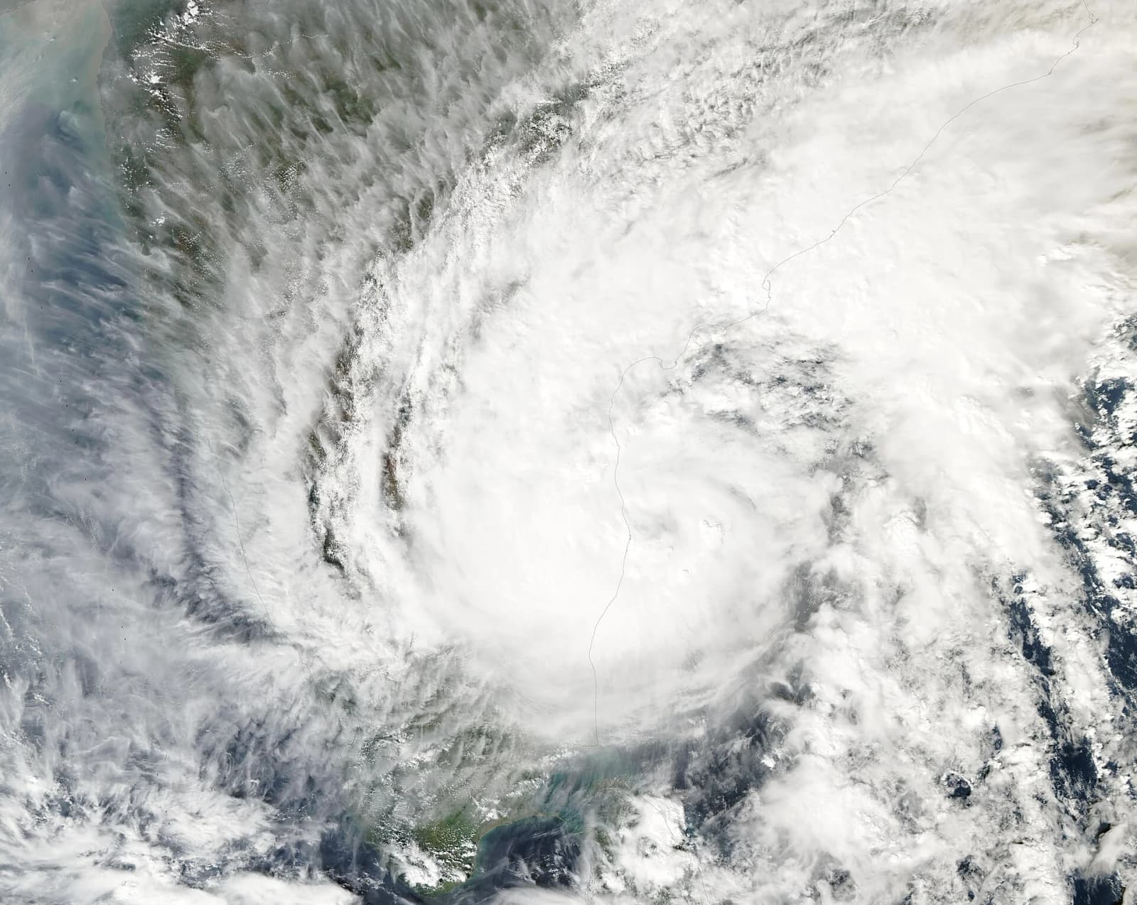
Severe Cyclonic Storm Akvan, churning over the Bay of Bengal, changed the picture for two states within a few hours on Wednesday, 18 November 2026. A morning bulletin from the India Meteorological Department (IMD) had the storm heading for the Andhra Pradesh coast between Nellore and Visakhapatnam. By the afternoon, the forecast landfall window had moved north to the stretch between Narsapur in Andhra Pradesh and Puri in Odisha, and IMD upgraded its warning for north Andhra Pradesh, Yanam and south Odisha to a "Red Message".
Here is what the weather office has said, how the forecast changed, what the states are doing and what remains unclear.
What happened on 18 November
According to IMD's National Bulletin No. 21, issued at 9.30 am, Akvan strengthened from a cyclonic storm into a severe cyclonic storm at 5.30 am on Wednesday. At that hour it was centred about 610 km south-southeast of Visakhapatnam and 580 km east of Chennai, and had been crawling north-northwest at about 3 kmph. That bulletin, carrying an "Orange Message", forecast landfall on the Andhra Pradesh and Yanam coasts between Nellore and Visakhapatnam around noon on 20 November, with sustained winds of 100-110 kmph gusting to 120 kmph.
The next bulletin, No. 22, issued at 1 pm, shifted the expected crossing to the North Andhra Pradesh, Yanam and South Odisha coasts between Narsapur and Puri, with winds of 90-100 kmph gusting to 110 kmph. An IMD press release issued at 1.30 pm described the window as running between Machilipatnam and Puri.
At 2.30 pm, National Bulletin No. 23 raised the alert to a Red Message. It placed the storm, at 11.30 am, about 540 km southeast of Narsapur, 600 km south-southeast of Kalingapatnam, 690 km south of Gopalpur and 750 km south of Puri. The system had sped up to about 8 kmph over the previous six hours. IMD said Akvan is likely to cross the coast between Narsapur and Puri by noon on 20 November as a severe cyclonic storm with sustained winds of 90-100 kmph gusting to 110 kmph.
How the forecast changed: a short timeline
- 17 November: Reports in Odisha and national media, citing IMD and its regional centre, spoke of a possible very severe cyclonic storm with winds of 120-130 kmph gusting to 145 kmph and a landfall between Nellore and Tuni in Andhra Pradesh.
- 18 November, 5.30 am: Akvan becomes a severe cyclonic storm, IMD says.
- 9.30 am bulletin: Landfall forecast between Nellore and Visakhapatnam; Orange Message for Andhra Pradesh and adjoining south Odisha.
- 1 pm bulletin: Window moves to Narsapur-Puri; storm surge warning now includes Ganjam, Khordha and Puri in Odisha.
- 2.30 pm bulletin: Red Message for North Andhra Pradesh, Yanam and South Odisha coasts.
Verified data from IMD's latest bulletin
The 2.30 pm bulletin, signed by IMD scientist Dr Suprit Kumar, lists these warnings:
- Rain: Heavy to very heavy rain at a few places and isolated extremely heavy falls of 21 cm or more over coastal Andhra Pradesh and south Odisha on 19 and 20 November. North Odisha is likely to get heavy to very heavy rain on those days.
- Wider rain belt: Heavy rain at isolated places over eastern Telangana on 20 November, Chhattisgarh on 20 and 21 November, Jharkhand on 20 and 21 November, and East Vidarbha and East Madhya Pradesh on 21 November.
- Storm surge: A surge of 0.5 to 1 metre above the astronomical tide could flood low-lying parts of West Godavari, Konaseema, Kakinada, Vizianagaram, Srikakulam and Visakhapatnam in Andhra Pradesh, and Ganjam, Khordha and Puri in Odisha, around landfall.
- Sea: Wave heights of 9 to 14 metres from 19 November, turning "phenomenal" at above 14 metres from the night of 19 November until landfall.
- Fishing: Total suspension of fishing in the southwest Bay of Bengal until 20 November, in the westcentral Bay until 21 November, and in the northwest Bay from 19 to 21 November.
IMD has warned of major damage to thatched and kutcha houses, power and communication poles, standing crops and plantations such as banana and papaya, and of possible disruption to railways, overhead power lines, signalling, airports and heliports. It has advised that coastal hut dwellers be moved to safer places and that rail, road and air traffic be "judiciously" regulated.
What the states are doing
Andhra Pradesh
Chief Minister N Chandrababu Naidu reviewed preparations on Tuesday by teleconference, according to the Deccan Chronicle. The newspaper reported that he directed officials to keep fishermen off the sea, send continuous weather alerts to vulnerable areas, prevent breaches in tanks and canals, and restore services quickly after the storm. Deputy Chief Minister Pawan Kalyan asked officials in red-alert districts to move people from coastal and low-lying areas and set up relief camps, the paper said. He noted that the two earlier cyclones this season, Arnab and Murasu, had damaged about 520 km of rural roads.
Odisha
The Odisha government has identified 1,902 vulnerable locations in 87 blocks across eight districts and prepared to evacuate more than two lakh people if conditions worsen, Argus News reported on 17 November. Ganjam alone accounts for over 1.21 lakh of that target. The state has listed 3,329 cyclone shelters, planned 74 ODRAF and NDRF teams and released Rs 6.5 crore in advance assistance, including Rs 5 crore for Ganjam, the report said.
On Wednesday, the state's General Administration department deputed four senior IAS officers to Puri, Jagatsinghpur, Gajapati and Kendrapada, Pragativadi reported, adding that leave for employees in vulnerable districts had been cancelled and beach tourism and water sports halted.
Background: a third storm in weeks
Akvan follows Cyclone Arnab, which hit the region in late October. On 29 October, The Tribune reported that 36 trains were cancelled and 30 diverted on the Howrah-Chennai route after the Bahuda river in Ganjam crossed the danger mark; East Coast Railway attributed the rise to about 550 mm of rain. Pawan Kalyan has said timely precautions prevented loss of life during Arnab and Murasu, the Deccan Chronicle reported.
Perspectives
IMD Director General Mrutyunjay Mohapatra said the system was moving north-northwest and its movement and intensity were being closely watched, OdishaTV reported. Odisha's Revenue and Disaster Management Minister Suresh Pujari has repeatedly said that protecting lives is the top priority, according to Pragativadi.
What it means for Indian readers
- Travellers: The Howrah-Chennai rail corridor and airports in coastal Andhra Pradesh and south Odisha fall in the warning zone. IMD has flagged possible disruption, so passengers travelling between 19 and 21 November should check status before setting out.
- Fishing communities and farmers: Fishing is suspended in large parts of the Bay of Bengal, and IMD has warned of damage to banana, papaya, coconut and other crops.
- Central India: Rain linked to the system is forecast to reach Chhattisgarh, Jharkhand, East Vidarbha and East Madhya Pradesh by 20-21 November.
What is established
- Akvan is a severe cyclonic storm over the Bay of Bengal, upgraded at 5.30 am on 18 November, according to IMD.
- IMD's latest bulletin carries a Red Message for North Andhra Pradesh, Yanam and South Odisha, with landfall expected by noon on 20 November.
- Fishing suspension, storm-surge and extremely heavy rain warnings are in force as listed in IMD's official bulletin.
What is uncertain
- Exact landfall point: The window is wide. IMD's 1 pm and 2.30 pm bulletins say between Narsapur and Puri, while its 1.30 pm press release says between Machilipatnam and Puri. Further revisions are possible as the storm nears the coast.
- Strength at landfall: Media reports on 17 November cited forecasts of a very severe storm with winds up to 145 kmph. IMD's 2.30 pm bulletin text says the storm will cross as a severe cyclonic storm with winds of 90-100 kmph, while the forecast table in the same bulletin shows it as a cyclonic storm of 60-70 kmph by 11.30 am on 20 November.
- Evacuation figures: The Odisha numbers are plans for evacuation "if conditions deteriorate", not completed moves. Andhra Pradesh had not published comparable district-wise figures in the reports we checked.
- Transport: Train and flight cancellations specific to Akvan had not been confirmed in the official sources we reviewed at the time of writing.
What happens next
IMD said it would issue its next message at 3.30 pm on 18 November and will keep updating bulletins as the storm moves. Its forecast table shows Akvan weakening into a depression by the night of 20 November and a well-marked low pressure area by midday on 21 November.