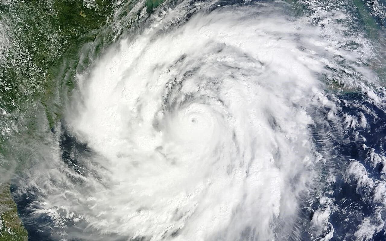
Severe Cyclonic Storm Akvan was moving north over the west-central Bay of Bengal on the morning of 19 November 2026 and is expected to hit land near Gopalpur in Odisha's Ganjam district by noon on 20 November, according to the India Meteorological Department (IMD). At 5:30 am IST on Thursday, the storm was about 530 km south of Gopalpur and 440 km east-southeast of Narsapur in Andhra Pradesh. Officials in both states have moved people inland, closed schools and stopped fishing.
Update (20 November 2026, 01:00 IST): Cyclone Akvan had not made landfall at the time of this update. In its national bulletin No. 33 issued at 20:30 IST on 19 November, the India Meteorological Department (IMD) placed the Severe Cyclonic Storm at 17:30 IST about 350 km south of Gopalpur and 420 km south of Puri, moving north at 13 kmph. IMD still expects it to cross the North Andhra Pradesh and South Odisha coasts close to Gopalpur by noon on 20 November, with sustained winds of 90–100 kmph gusting to 110 kmph, and forecasts it to weaken into a Cyclonic Storm around landfall and a Deep Depression by the evening of 20 November. The bulletin warns of a storm surge of 0.5–1 metre in low-lying parts of Ganjam and Puri in Odisha and Kakinada, Vizianagaram, Srikakulam and Visakhapatnam in Andhra Pradesh, and of isolated extremely heavy rain (21 cm or more) over Odisha on 19 and 20 November. Odisha officials said on the evening of 19 November that more than 1 lakh people had been evacuated, including over 45,000 in Ganjam district, according to ETV Bharat. No deaths had been reported.
This explainer covers the official forecast, how the storm developed, what each state is doing, what it means for people in and beyond the two coastal states, and which details are still uncertain.
What has IMD forecast for landfall?
IMD expects Akvan to cross the North Andhra Pradesh and Yanam coast and the South Odisha coast between Narsapur and Puri, close to the east of Gopalpur, by noon on 20 November. It forecasts sustained winds of 90–100 kmph with gusts up to 110 kmph at landfall. IMD's National Bulletin No. 29, issued at 9 am on 19 November, carries a "Red Message" cyclone warning for the North Andhra Pradesh and Yanam coast and the South Odisha coast.
The bulletin's forecast table expects the storm to stay at severe cyclonic storm strength until early on 20 November. It then weakens to a deep depression with winds of 50–60 kmph by 5:30 pm that day, and to a well-marked low-pressure area by the morning of 21 November.
- Rain: Heavy to very heavy rain at a few places, and extremely heavy rain (21 cm or more) at isolated places, over north coastal Andhra Pradesh and south Odisha on 19 and 20 November. North Odisha is also forecast to get heavy to very heavy rain.
- Storm surge: A rise of 0.5 to 1 metre above the astronomical tide may flood low-lying areas of West Godavari, Konaseema, Kakinada, Vizianagaram, Srikakulam and Visakhapatnam districts in Andhra Pradesh, and Ganjam and Puri districts in Odisha, around landfall.
- Sea: In the west-central Bay of Bengal, IMD forecasts waves of 9–14 metres from 19 November, rising above 14 metres from Thursday night until landfall.
- Damage expected: IMD lists major damage to thatched and kutcha houses, power and communication poles, standing crops and banana and papaya plantations. It also expects disruption to rail services, overhead power lines and signalling systems.
How did Akvan develop? A timeline
- 16 November: In its 9:30 am bulletin, IMD classified the system as a deep depression over the southeast and adjoining southwest Bay of Bengal, about 820 km south-southeast of Visakhapatnam, according to an Outlook report.
- 17 November: The system became Cyclonic Storm Akvan, according to IMD's press release of the following day.
- 18 November, 5:30 am: It strengthened into a severe cyclonic storm. IMD's press release issued at 1:30 pm placed it 710 km south of Gopalpur and gave a landfall window between Machilipatnam and Puri.
- 18 November, afternoon: Odisha TV reported that IMD had revised the track, with landfall now expected between Narsapur and Puri.
- 19 November, 5:30 am: The storm was about 530 km south of Gopalpur and had moved north at 12 kmph over the previous six hours. IMD narrowed the expected landfall point to near the east of Gopalpur.
Where does the name Akvan come from?
Iran suggested the name. Thirteen countries contribute names for cyclones over the Bay of Bengal and the Arabian Sea, and the names are used in a fixed order. A storm gets its name once its sustained winds reach about 62 kmph (34 knots). Outlook and Oneindia link the name to Akvan-e Div, a demon-like figure in the Persian epic Shahnameh by the poet Ferdowsi. Oneindia notes that the official list gives no English translation of the name. According to Outlook, Akvan follows Cyclones Arnab and Murasu, which hit India's east coast in the preceding weeks. Outlook says reports put the crop damage from those two storms at more than 4.5 lakh hectares.
What is Odisha doing?
Odisha Chief Minister Mohan Charan Majhi said on 18 November that the state was aiming for zero casualties and that most evacuations would be in Ganjam district, according to The Business Standard. He said the state had 3,000 cyclone shelters, of which 448 were already in use. People are being moved from villages in Ganjam, Gajapati, Kandhamal, Rayagada, Koraput and Malkangiri districts.
Odisha TV's live coverage reported these steps:
- 46,701 people had been evacuated by the morning of 19 November.
- The state sanctioned Rs 6.5 crore for evacuation and preparedness.
- The Special Relief Commissioner's office shut beach tourism.
- Khordha district cancelled leave for government staff until 23 November.
- Kandhamal district closed the Kalinga Ghati road because of landslide risk.
- East Coast Railway rescheduled 23 trains due to run between 18 and 20 November.
Down To Earth reported that about 60 Odisha Disaster Rapid Action Force (ODRAF) teams and 14 National Disaster Response Force (NDRF) teams have been deployed in the state.
Odisha TV, citing IMD, reported a red warning for very heavy rain in Ganjam, Gajapati, Puri, Jagatsinghpur and Kendrapara. Manorama Mohanty, director of IMD's Regional Meteorological Centre in Bhubaneswar, advised people in vulnerable areas to stay in safe shelters and avoid unnecessary travel. She also warned people in hilly areas prone to landslides.
What is Andhra Pradesh doing?
According to Deccan Chronicle's live coverage, the Andhra Pradesh government's RTGS asked the north coastal districts of Srikakulam, Vizianagaram, Visakhapatnam and Kakinada, and the Godavari districts, to stay on alert for 24–36 hours. Seas were rough along the Srikakulam coast, and fishermen had pulled their boats ashore. Andhra Pradesh has put its disaster response teams and fire services on standby, according to Down To Earth. None of the reports we checked gave an evacuation figure for Andhra Pradesh.
What does this mean for readers across India?
- Train travel: Trains on the east coast corridor are being rescheduled. Deccan Chronicle reported that the Charlapalli–Shalimar East Coast Express (18046), the Secunderabad–Howrah Falaknuma Express (12704) and the SMVT Bengaluru–Muzaffarpur Express (15227) were rescheduled on 19 November. Passengers should check their train's status before leaving home.
- Rain beyond the coast: As the storm weakens inland, IMD forecasts heavy rain at isolated places over eastern Telangana on 20 November, Chhattisgarh and Jharkhand on 20 and 21 November, and East Vidarbha and East Madhya Pradesh on 21 November. Gangetic West Bengal may get very heavy rain at isolated places on 20 November. MapMyTimes has reported the rain alert for Madhya Pradesh linked to Akvan.
- Farms and fishing: IMD warns of major damage to standing crops and horticulture. It has advised fishermen not to go out to sea, with the ban lasting until the morning of 21 November in the west-central and north-west Bay of Bengal.
What is established, and what is uncertain?
Established (from IMD's bulletins)
- Akvan is a severe cyclonic storm. At 5:30 am on 19 November it was about 530 km south of Gopalpur.
- IMD's latest bulletin expects landfall between Narsapur and Puri, close to the east of Gopalpur, by noon on 20 November, with winds of 90–100 kmph gusting to 110 kmph.
- A storm surge of 0.5–1 metre is forecast for named districts of Andhra Pradesh and Odisha. Extremely heavy rain is forecast at isolated places on 19 and 20 November.
Uncertain or reported differently
- Strength at landfall: IMD expects the storm to reach the coast as a severe cyclonic storm. Deccan Chronicle reported that Andhra Pradesh's RTGS expected it to weaken before landfall and cross north of Srikakulam as a deep depression or cyclonic storm, with winds of 60–70 kmph.
- Earlier forecasts: On the morning of 18 November, Odisha TV quoted the Bhubaneswar weather centre as forecasting a "very severe" storm crossing Andhra Pradesh between Nellore and Tuni, with winds of 120–130 kmph. IMD's current forecast is weaker and further north. Forecasts can change again before landfall.
- Evacuation figures: Odisha TV reported 46,701 people evacuated. Other outlets reported about 50,000. No official final figure was available.
- School closures: Some reports said schools were closed in six Odisha districts and others said 11. These figures may reflect orders made at different times.
What happens next?
IMD will keep issuing bulletins as the storm nears the coast. According to the forecast table, the worst winds and sea surges are expected in the hours before and around noon on 20 November. After landfall, the storm is forecast to move north-northwest over Odisha and weaken quickly. Rain is expected to move inland into Chhattisgarh, Jharkhand, West Bengal, Vidarbha and eastern Madhya Pradesh on 20 and 21 November. Residents of the warned districts should follow local administration instructions and IMD updates.